
A Search for the Unicorn of Williamsville
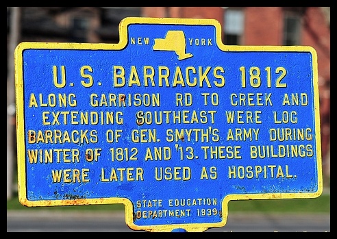
This sign often confused me at first — why would they build their barracks away from Ellicott Creek? If as the sign stated "along Garrison Road to creek and extending southeast," it would take you away from the creek. Who would want to carry water any further than they had to, especially in the winter? Well, that is what set off my quest for the Barracks.
The Barracks and Hospital in Williamsville has almost mythical status. It might be termed the Unicorn of the village — often spoken of and imagined but never seen.
The first thing I noticed in my search was that it wasn't referred to as "barracks" or a "garrison" at Williamsville. Its official name was the Cantonment at Williamsville. Cantonments are places of encampment formed by troops for a more permanent stay, or while in winter quarters.
My first steps were to find the oldest maps of the Village of Williams and Amherst. The first was a map of the village in 1854; the next, 1866. Both showed Garrison Road — prior to that name it was the Lancaster Road (as recent as 1851, which I noticed on a deed), and before that it was originally known as the Colborn Settlement Road.
All contemporary writings said that during the War of 1812 the village was known as Williams Mills, but this is not the case. In many letters from military officers and doctors stationed there, it was always referred to as Williamsville or Williams Ville.
"The hospital at Williamsville, about 19 km east of Buffalo. The site was picked on 29 July on the recommendation of the senior surgeon, Dr. Ezekiah Bull. Thus, 37 ha and the stables of Raphael Cook's farm were leased for the construction of a general hospital. Ironically, the contract specified 'no burying place in the premises.'"
— Snake Hill: An Investigation of a Military Cemetery from the War of 1812I have a theory about why this site was chosen. If you were going to build a hospital or barracks in the early 19th century, the first thing you would need is fresh water. Not creek water — you would get your men sick if they had to rely on creek water. That is where Lehn's Springs comes in: plenty of fresh water, and it was outside the Village limits at the time.
That land was owned by Gamaliel St. John, who purchased Lots 8, 9, and 20 in Township 11 Range 7, and Lot 24 in Township 12 Range 7. Lot 20 in Township 11 Range 7 — present-day Lehn Springs Development — is the one that interests me most. It is actually outside the Village, in what was then Cheektowaga according to the Holland Land Company Survey maps.

Figure 5 — Lineage Book by Daughters of the American Revolution
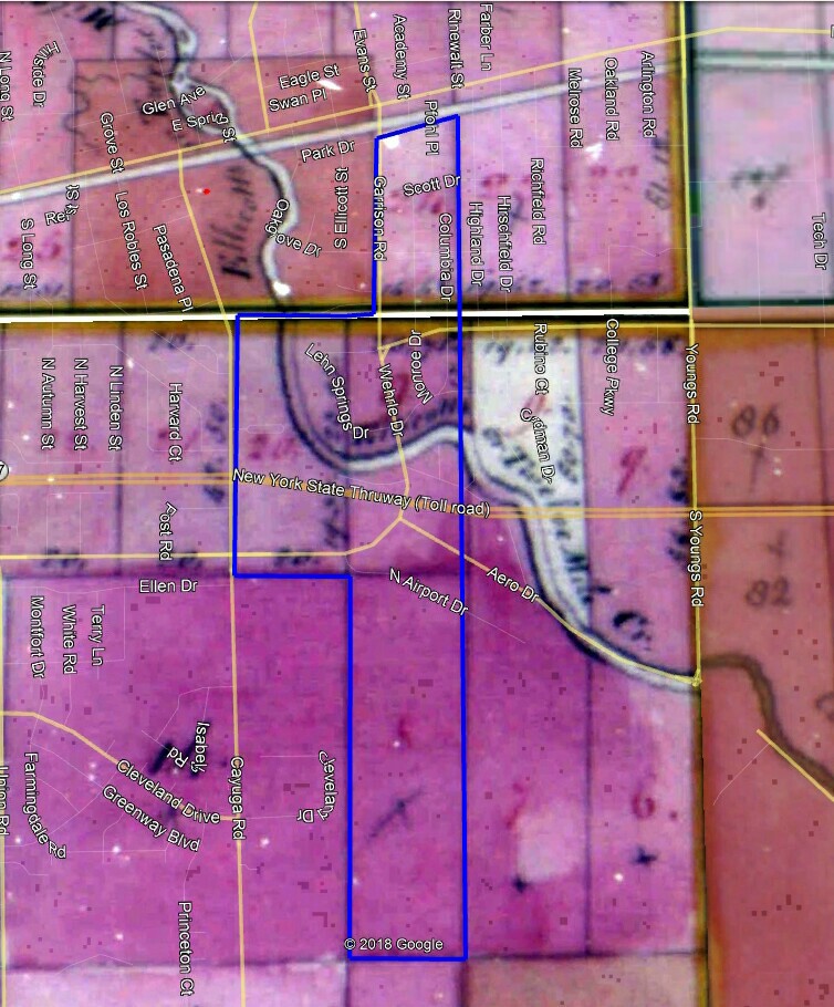
Figure 6 — Holland Company Survey Maps of Townships 11 & 12 Range 7. Blue outline shows Gamaliel St. John farm overlaid on Google Earth.
The Frick family lived on the St. John Farm until the War of 1812. The Amherst Bee of August 16, 1923 published a history of the Lehn Family, prepared by Ida L. Zent and read at the Old Home Day Reunion on August 4, 1923, which states matter-of-factly:
Just like everyone knew where the barracks were in 1923. The story also confirms that John Frick, who lived there, "fell a victim to overwork" while caring for the sick and wounded soldiers and died on the farm.
I believe that after Frick's death and the burning of Buffalo, his family returned to Pennsylvania and placed the farm in the care of Raphael Cook — who then leased part of the land to the government for the hospital. Lots 9 and 20 of Township 11 Range 7 of the Frick farm are each approximately 90 acres, matching the 90 acres recorded as leased in Snake Hill.

Figure 7 — Holland Company Survey Maps with proposed search area. The green circle marks the Frick/Lehn Farm site near the northeast corner of Garrison Road and Wehrle Drive.
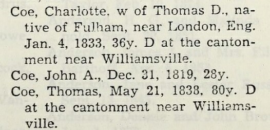
Figure 8 — Obituaries from Early Settlers of New York State: Charlotte Coe and Thomas Coe both recorded as dying "at the cantonment near Williamsville."
It clearly states in both obituaries: "D at the cantonment near Williamsville." So presumably the Cantonment was not in Williamsville, but near it. Williamsville at the time was designated as Lot Number One in Township 12 Range 7 — it contained 300 acres. The Thomas Coe land in the yellow boundaries falls outside those limits.

Figure 9 — Buffalo Gazette, August 29, 1814. Dr. Bull's reward notice refers to the Hospital Lot as "near Williamsville."

Figure 10 — Jonas Williams deed to Township 12 Range 7 Lot 1, dated April 20, 1808
Figure 11 — Present-day boundaries of Lot 1 in red
The 1927 Photographs & the White Dots
With fresh water at Lehn Spring, a location near but not in Williamsville, and a site within a quarter-mile of the Frick/Lehn farm — I turned to aerial photography to see if any trace remained.
The Fairchild Aerial Surveys of 1927 proved to be the key. In the photograph of the Frick/Lehn Farm area, a line of white dots in the middle of a meadow — with nothing else around them — had perplexed me for the longest time. Then it finally came to me.
I believe the lines of white circles in the meadow are the remains of the soldiers' huts. The white piles are the stone used for the fireplaces in the huts. This area was outside Williamsville at the time. It is now the Lehn Springs Development.
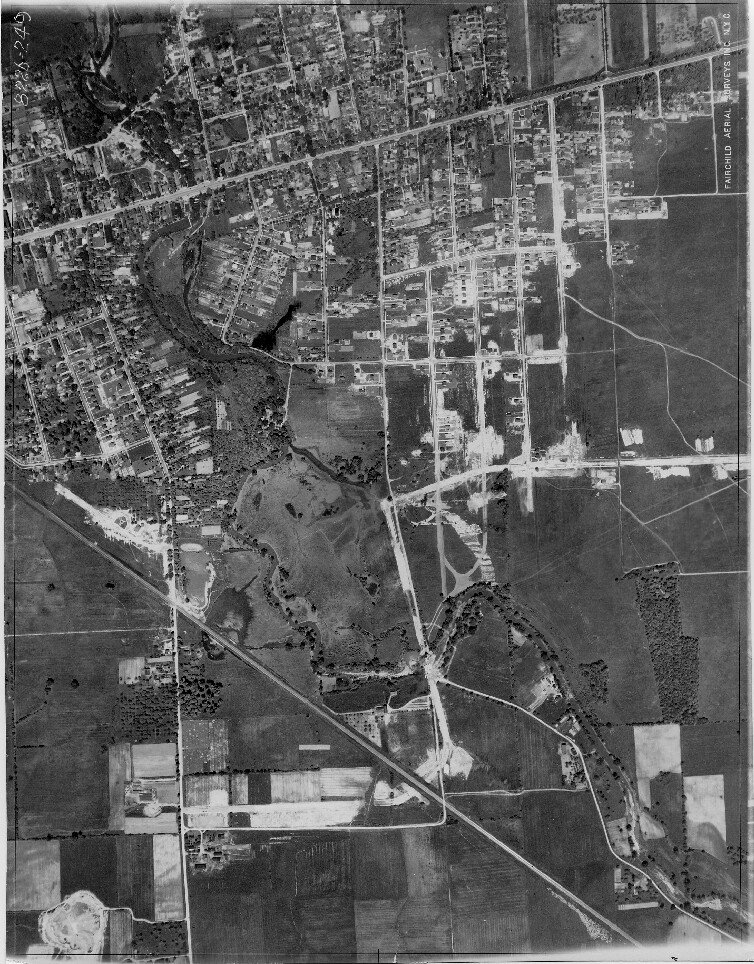
Figure 12 — Aerial photograph from Fairchild Aerial Surveys, 1927

Figure 13 — Aerial photo with site markers from Fairchild Aerial Surveys, 1927
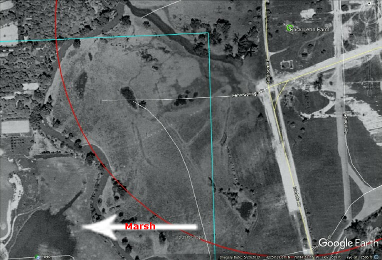
Figure 14 — Aerial photo of the marsh area mentioned by Dr. Joseph Lovell in his campaign report
"On the first of August 1814, the Williamsville hospital was designated as a general military hospital, and Dr. Joseph Lovell was appointed hospital surgeon. In his report of the campaign of 1814, he states that a thick fog arose from marsh and woods at sunset — undoubtedly largely accountable for the intermittent fever, acute rheumatism and typhus that broke out among the men."
— Niagara Frontier Miscellany, Buffalo Historical Society, p. 101In Figure 14, the lower left corner is believed to show the location of the very marsh Dr. Lovell describes. Everything fits: the water source, the marsh, the proximity to the Frick farm, and now the physical traces from the air.
The Soldiers Huts
The first soldier huts built in the area are referenced in a letter dated December 12, 1812. Eleven Mile Creek — now Ellicott Creek — was called that because at the point where it crosses Main Street it was approximately eleven miles from the Village of Buffalo.
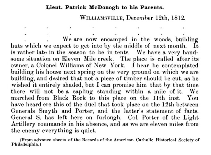
Figure 15 — Letter dated December 12, 1812: Lt. Patrick McDonough to his parents. Source: The Documentary History of the Campaign Upon the Niagara Frontier in The Year 1812

Figure 16 — Passage from Rev. Albert Bigelow, The Early Firm of Juba Storrs & Co., p. 117. States the barracks and hospital were "about a mile from Williamsville up the creek."

Figure 17 — The Army Medical Dept., 1775–1818: Early Campaigns in the North: 1812–1813, p. 169

Figure 18 — Corresponding footnote #57, p. 260
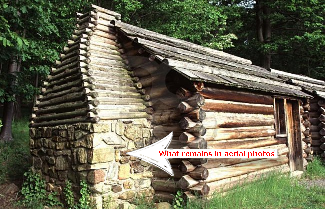
Figure 19 — Valley Forge Soldier's Hut Model. I believe the same type was constructed for the War of 1812 — hut technology had not advanced much in those decades.
Recorded Deaths at the Hospital at Williamsville
The death register compiled by Jack Bilow from War of 1812 records gives us a year-by-year account of the toll taken at Williamsville — a toll that surged dramatically after the battles of Chippewa, Lundy's Lane, and Fort Erie in the summer of 1814.
The Location & Conclusions
I believe that the Cantonment — which contained the Barracks, Huts, and Hospital — was located in the present-day Lehn Springs Development area. The white dots seen in the aerial photo from 1927 are what remained of the last piles of stones from the fireplaces in the soldiers' huts. All of the clues have brought me to this area.
First: the account of Ida L. Zent of the Lehn Family, read at Old Home Day Reunion August 4, 1923, stated the family farm was less than a quarter mile away from the barracks, and that John Frick died of exhaustion while caring for the sick and wounded soldiers.
Second: the Charlotte and Thomas Coe obituaries state that both died at the "Cantonment near Williamsville" — confirming the site was near, not in, the village.
Third: the Buffalo Gazette of August 29, 1814 advertisement by Dr. Bull refers to the "Hospital Lot as near Williamsville."
Fourth: Dr. Joseph Lovell's mention of a thick fog arising from marsh and woods at sunset — consistent with the marsh visible in the 1927 aerial.
Fifth: the Holland Land Company Survey Maps showing that Lot 20 was in Township 11 Range 7, not Township 12 Range 7 — placing it outside the village limits.
Sixth: the letter from Lieutenant Patrick McDonogh, December 12, 1812, stating they were building huts on the Eleven Mile Creek.
If you follow the known wagon roads from the Evans House (the Army's temporary headquarters) to the proposed location in Lehn Springs Development, it is .87 miles — about a mile — precisely the distance recorded in contemporary sources.

Figure 20 — 1927 Aerial Photo of Lehn Springs area overlaid on Google Earth, showing the white dot locations

Figure 21 — Present-day Lehn Springs Development. The red outline marks where the white dots appeared on the 1927 aerial photo.

Figure 22 — Present-day Lehn Springs Development with possible hut locations. Black rectangles represent War of 1812 soldiers' huts (approx. 16' × 14').

Figure 23 — Soldiers' Hut Dimensions from Valley Forge Models

Figure 24 — 1815 Map. The two circles just below the Batavia Road where it crosses Ellicott Creek are believed to designate the Army Headquarters and the Hospital Cantonment — approximately one mile apart.
Williamsville and the War of 1812
More on the War of 1812 Hospital Cantonment and Soldiers Huts at Williamsville, New York — including the full documentary record, aerial overlays, and the complete account of the search — is available in this book by J. A. Buscaglia.
View on Amazon →